Finding out about my work schedule on short notice, Isy and I were left with a goofy plan for the coming weeks. We went to New York & Boston for only a few days after that work conference, but I also needed to be back in Newfoundland the next week. At the same time, we long had plans to go on a 10-day road trip in late June. Therefore we flew back to Newfoundland on Sunday afternoon, just to spend 5 days there, change the car's oil, pick up the dog, load up & head south. |

One of the newer ferries wasn't running, so we were instead on the old MV Leif Ericson. Pulling into the car lineup to board the vessel, the ticket agent had apologized for this inconvenience. There was no need for apologies though, as this was one of the boats from when I first came to Newfoundland, where there's a bunk room and you can get a sleeping berth for a mere $26. This is vastly different than the norm nowadays, where all of the new boats are designed not for people who live in Newfoundland, but for tourists who want to spend upwards of $700 round trip in order to have a cabin and this luxurious, Instagrammable adventure to Newfoundland and Labrador. (Insert blowing pitcher plant logo and #explorenl here.) I was psyched that we were back on the old bare bones boat laying atop comfortable-enough mattresses, instead of sleeping on the floor of the TV room to avoid paying $145 each way for a private cabin. |

The goal of this trip was to take advantage of our 10-day window and cover a lot of ground into territory that's not as familiar as the Maritimes or New England. The dog still needed to use the washroom though, and having recently checked out the old Bridge Street Bridge in Sackville New Brunswick that's visible from the Trans-Canada Highway, we pulled off right near the start of New Brunswick to gas up and stretch the legs. |

With the central part of this bridge missing, it's a sheer drop down to the muddy banks of the Tantramar River. Those brown banks come from the sediment-rich waters, the flat country, and the Bay of Fundy's highest tides churning water in and out of here twice a day. There are similar rivers in both Moncton and Truro, and I always wondered what would happen if someone got too close and slipped on that mud into the river. There are animal deaths from when they get stuck in this mud, but reading about it, most humans can manage to balance enough to get out, or at least stick there long enough for help to come. |

We'd been driving for about 4 hours when we reached Sackville and there was still another 4 hours ahead of us before we got to our campsite. We'd gain an extra hour by moving into the Eastern Time Zone, but that would mean little when we were concerned with the sunset time rather than some campground's closing time. That's because we were going to a place I'd found on FreeCampsites.net, where up here in Maine there were some maintained campsites in the Machias River Corridor Public Lands. |

We quickly scooped up beers and ice at the liquor store in Calais Maine, before the sub shop took a while and ate up more of our remaining daylight. Regardless, the border crossing was relatively painless and we'd made short work of this 8-hour driving day. After just 40 more minutes of driving, we were pulling off Maine State Route 9 and into a deserted, 6-site camping area. Why yes, we would be taking the site with the log lean-to. |

We certainly could have made it farther and balanced out the days better, but I couldn't pass up this campsite when I came across it in my pre-trip research. If we would have kept going, it would have been paid campgrounds or maybe a motel in Bangor, which just wasn't going to work. This area of down east Maine is empty enough that I also figure you could stealth camp somewhere, but I've never tried it. |

The Machias River flows 76 miles from Fifth Machias Lake down to tidewater in the coastal town of Machias. There are multiple spots to put in a canoe along this route & that seems to be the main factor of why these campsites exist. I was a bit confused by the Airline Rips name of this campground, but the Airline part comes from the Airline Stage Company, which started a stagecoach run on this road in 1857. The "rips" part of the name comes from the fast-flowing or rough water here, aka the "rips". |

Isy brought cookie dough and thought she would make warm cookies over the campfire. It failed spectacularly and she would not recommend you try the same, lol. |

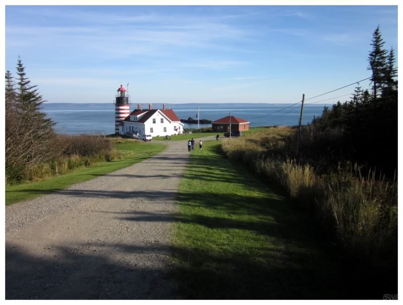
The next day we were up early enough and ready for another day of driving (today it was 8.5 hours according to Google). Instead, we ended up in stop and go traffic down in Connecticut yet again, to the point that when we pulled off into a rest stop, I felt a sense of relief as if I'd just finished public speaking or successfully rode away from something on my bike. It was just endless stop and go, then full stops, then race up to 50mph just to immediately brake, over and over and over. I told Isy that I think Connecticut might be my least favourite state. Ticks, private lighthouses and these damn roads - that's a lot for my love of Hartford to overcome. |

Isy's photo.
At least we ended up going through NYC a little later in the day and that seemed to help with traffic? |

By the time we got on the Garden State Parkway, I was ecstatic that the traffic had thinned out because it had officially become fuck this shit o'clock. The one good thing about running so late and taking so much time was that it was now completely dark outside. Usually there's a rush to put up the tent as I always get us to campsites right at sunset, but with it being dark, I had time to go and use the sweet, 1970sish washrooms at the New Jersey State Park we'd reserved. Back at the campsite, I carefully stepped around vegetation and leaves to stay away from ticks, while the restless dog was tied to the picnic table and paced, displeased that he had to spend all this time in the car just to be fastened to a New Jersey picnic table. We enjoyably put up the tent and inflated the mattress as we took our time, eventually firing the mattress into the tent and lounging atop it in the sweaty night, relieved that we had made it and there was little left to do today. |

"What's that on my leg, look, that's a tick!!? Is that not a tick?!?" Isy exploded out as I tiredly sat up and agreed that the little dot on her leg looked like a tick. And then she found another one. And that just about settled it. She asked if I thought it was fine to stay here in the tent, but I didn't know how many more ticks there would be or how bad this state park was for them. I agreed with her that we should get going. So we deconstructed our giant tent that's the size of a destination wedding gazebo, squeezed all the air back out of the air mattress, fought with the surly dog to get him back into the car, then looked up a nearby motel. The 3.2-star Executive Inn & Suites in nearby Tinton Falls? Cool, yep. As soon as we opened the door to our motel room, the dog nosed in and flopped right down, clearly tired with our shit. Isy and I would proceed with the tick check and fail to find even one more on either of us or any of our gear. This lack of ticks always makes me wonder if we could have simply stayed at the campground, but we probably wouldn't have got much sleep. Oh well, if we were mountaineers, we'd passed the crux of our journey (driving through CT and NYC) after doing 19 hours of driving and 8 hours of ferrying. It was now time for our reward. |