If I was going to be over on the Avalon exploring the Bay de Verde Peninsula, then I always find it hard to say no to a Burin Peninsula sidetrip.
More specifically I was excited for the 'arm' of the peninsula, which held many villages which I had never taken the time to see.


After driving through 65km of high barrens upon the arm of the Burin Peninsula, I finally turned west on NL-211 towards Terrenceville, Grand Le Pierre & English Harbour East. Terrenceville had a nice waterfall and sand spit, but as you can see, it was mostly overcast.

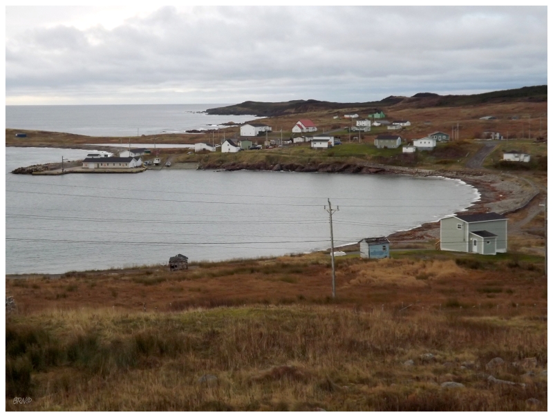
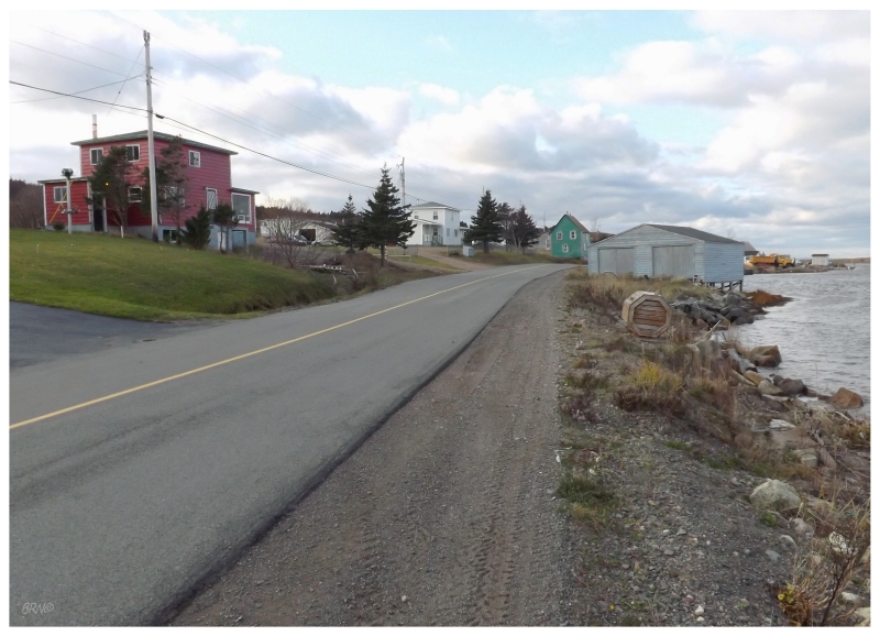
Instead, all three of these pictures come from English Harbour East - the type of rural place which has a bridge with a 20t limit so kids have to walk to meet the school bus.

The majority of the day had been eaten up by driving from the motel near the Bay de Verde Peninsula, plus the drive down the Burin Peninsula, as well as the NL-211. By the time Parkers Cove was visited once back at the highway, it was already getting into the afternoon & legitimate reservations meant that we needed to get to the town of Burin.

I booked a place in the town of Burin because I've wanted to see a movie in their tiny, throwback theatre for many years now. Unfortunately something mediocre was playing the first time I was here, so I skipped out on attending.
This time I resolved to go no matter what was playing.
Unbelievably, it was opening night for the new Twilight...in the only cinema on the Burin Peninsula, a small, intimate theatre - the perfect storm of what could force me to stay away.
A friend from work was dragged to Twilight and said girls were taking flash pictures of the screen. So I'm going to go and put up with swooning/crying, flash pictures of the screen, awkwardness as to why I'm there & being an outsider in a place where everyone knows everyone else?
I considered doing it for the humour of it all, but eventually decided against it. I'm sorry. I went and had mediocre Chinese at Burin's Lucky House instead. The Lucky House must have been something else originally, because it had strange greenhouse-like windows like a Harvey's would have; which were quite drafty seeing as it was November.

The next day included a spin around the 160 km, Burin Peninsula loop road; even if it wasn't the nicest day out.
The above beacon is the Middle Head Lighthouse, which I also saw in the summer of 2011 (under similar conditions).

I was surprised to see a Snow Bunting land nearby as I climbed a ridge to shoot down on the Middle Head Lighthouse.
The conditions had taken a turn for the worse ever since leaving Epworth 30 km ago, so it was interesting to see the Snow Bunting fight the wind and moisture to land near me for a few fleeting seconds, before propelling itself upwards into the wind and flying away.
Continuing along the road, we passed through communities with great names like Lawn, Calmer and the above Lord's Cove. All of them are along the NL-220 so I've seen them before, but I took a few more minutes to snap pictures and explore this time.

After all of this stopping - including at Lamaline's Allan Island Lighthouse and Fortune's Fortune Head Lighthouse - a hunger was developed that would be squashed in my beloved Grand Banks.
Although this town has a demolished a few buildings recently, they still have a great stock & they seem to be somewhat trying for a place with a closed fish plant and relative isolation.


So I finally went for a walk around Grand Bank, which I've wanted to do in each of the past three or four visits I've taken here.
It wasn't the warmest day as a brisk wind was coming off Fortune Bay, but enough warmth was achieved while quickly moving along the side streets, enjoying the widow's walks, unique windows and other interesting features amongst these Grand Banks houses.

After getting Molliers for community #696 on the island, we came across a turn for Famine Point and automatically pulled off. I didn't have it on the list, but since we were here we might as well see Famine Point & Grouse Point.
It was worth it simply for the above picture, which I call, "would you like famine or grouse?" :D

Not surprisingly, Famine Point was the cooler of the two communities.
Grouse Point was similar to Molliers, in that it was mostly small/newer cabins mixed with trailers.

Speaking of great communities, I really liked Grand Beach, which we would find another handful of kilometers up the coast.
So where's the picture of the grand beach you ask? Well these houses were much better!
(The beach was grand for the Burin I suppose, but it was separated by the town by a tickle, so it remained as a distant view from the end of town, instead of being able to park and explore said beach.)
We would continue onto Marystown, driving the NL-222 to Winterland Airport simply because I hadn't drove it before. Actually acquiring a reasonably priced motel in Marystown by avoiding the Marystown Hotel, we checked off Little Bay East & Beau Bois at dusk, which was unfortunate because Beau Bois was really beautiful but I decided against setting up my tripod.

Waking up in the morning I was excited as I thought the interestingly-named community of Spanish Room would make 700...but apparently my math was off & Spanish Room was only 699! Oh no!

The uninspiring name of Rock Harbour made 700.
The funny thing was that Rock Harbour had a beautiful bay, wandering cats and an impressive church upon a hill, with tombstones cascading down to the east...while Spanish Room was a drive-thru community with a couple of gaudy McMansions.
Don't judge a book by its cover, or community name, I suppose.

The better part of the morning was spent driving through villages on the eastern side of the Burin arm, through such places as Rushoon, Red Harbour, Jean De Baie and the above Baine Harbour.
The sun would come out in Baine Harbour, so it was an obvious choice for photographing.

Baine Harbour was the last of the eastern ones for today because we needed to make it back to CB and there was a sizable network to the west. Knowing the terrain of eastern Bay d'Espair from memory and English Harbour East from yesterday, I was quite excited for this drive since I figured the coast to be rugged and the towns superimposed upon whatever piece of land they could find.

Driving all the way to the end at Harbour Mille, I was not disappointed. I'm not sure what employs all of these people, but I can't imagine the infrastructure around here is cheap to maintain. We drove besides steep cliffs and over shallow causeways, out on spits of land surrounded by the mighty Atlantic.
Anyway, add Harbour Mille to the top 10 for the province. I don't know how a tourist would have any idea of how beautiful of place this is, but it's a shame that they wouldn't know without extensive research. I think of Harbour Mille when I'm traveling now, pushing forward with extra research in hopes I find these special, off-the-beaten-path places.

We went for a bit of a hike in Little Bay East, since I've read obscure references to a 'lighthouse' at the end of a trail. I doubt it's a legitimate, count-it lighthouse; but I still wanted to see for myself.
This would result in failure, but I'm not losing any sleep as I still believe it's simply a modern steel structure or a spot where a lighthouse stood long ago.

All of the communities over here held water in terms of my expectations.
Bay L'Argent gave pause though, until it was figured out that it looked strange because they actually had fences along the road.

I thought Jacques Fontaine (pronounced Jack Fountain) would be extra special because of a vacant high school...

...until I crept up and realized it was being used for RV storage!
Okay, okay. Enough counting towns and community updates. Back to CB!
Exploring the Burin Arm would give me a total of 711 out of 798.
Unfortunately I left a couple behind as I had future plans to revisit this area, but it is proving to not be a priority.
Will they remain as the last communities between myself & 798?