I awoke flustered by a noise I didn't expect out here, the engine rumble of a passing truck. In such a distant place it's likely that humans will check on each other, but just as soon as I heard the truck, it had passed me by & continued down the road. |
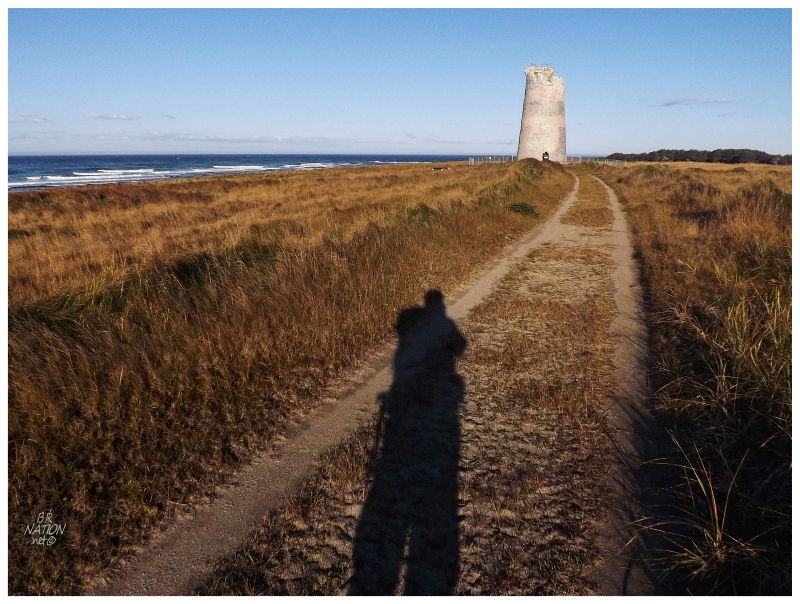
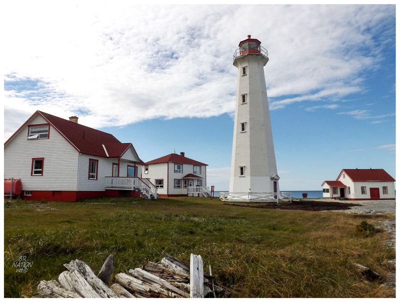
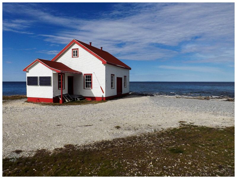
It was already a hot day, feeling hotter than any afternoon over the whole trip; which was astonishing considering that it was now even later in September. Packing up my water & snacks, the truck hadn't returned and it wasn't along the road beside Anse Gibbons (Gibbons Cove) either. Doing the same walk in a short amount of time, the second time never seems as long as the first. Before long, I was cutting into the forest & almost stumbled right upon the empty, parked truck. Apparently a cabin I had noticed last night and thought about checking out this morning, was more occupied than I thought. As if this person was going to scold or detain me for being here, I scurried along until the track turned sandy and the trees let off. Phare du Pointe Sud Ouest was finally up ahead. Forgetting that truck, I was now living the daylight moment I'd envisioned for months. |
Browsing the incredible UNC Lighthouse Directory like I often do, it was the sight of Southwest Point Lighthouse that arrested me & immediately made me contemplate visiting Anticosti Island. In addition, another website called Lighthouse Friends had recently visited Anticosti & Kraig's descriptions, photographs and anecdotes made me yearn to come here even more. |

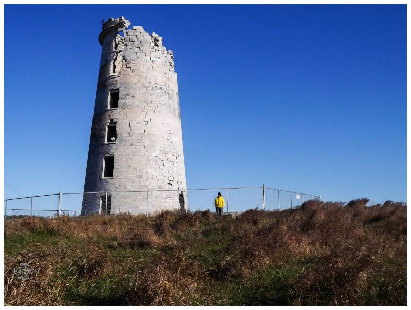
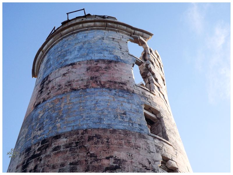
The first pictures I saw of this lighthouse were even more dramatic, because even though it was abandoned in 1959, the lantern room only collapsed into the interior sometime around 2011. Looking at Panoramio, you can see 2008, 2010 and 2011 photos showing the intact lantern room atop the tower. Southwest Point even influenced when I would visit Anticosti Island. I had originally only seen the photos with the lantern room, resolving to 'one day' visit Anticosti Island and see this sight. It was only after a few years that I read a Lighthouse Friends post & realized the lantern room had collapsed. I saw this as a sign not to waste anymore time & see what could be seen before even further collapse occurred. |
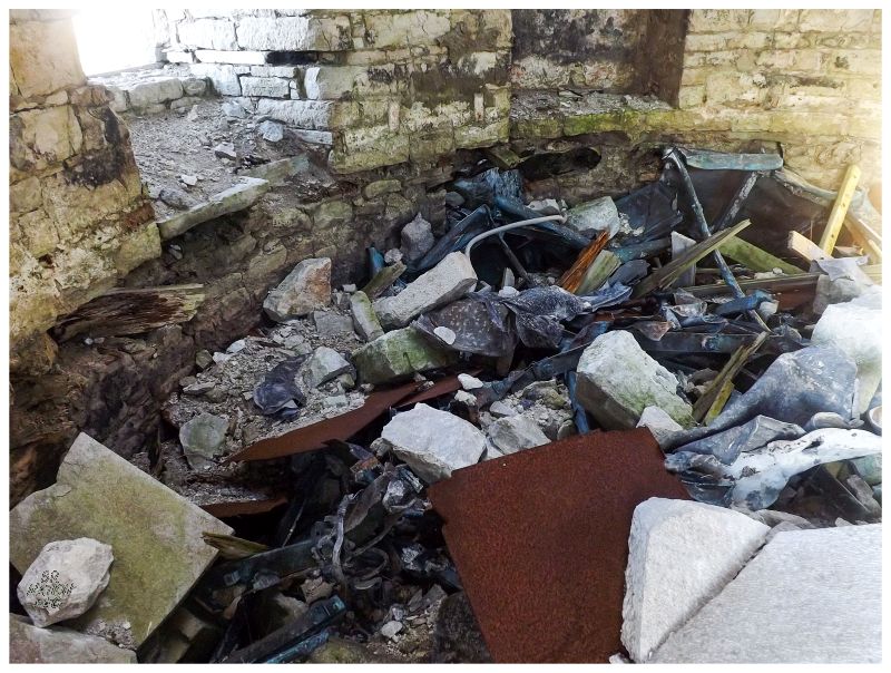
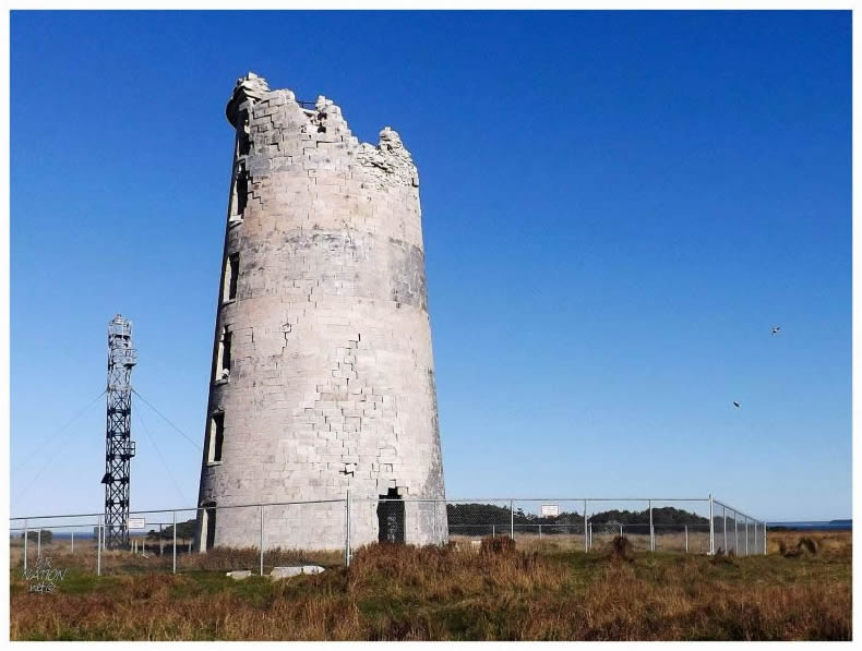
Peeking inside, I could make out lantern room shrapnel and what looked like the patina of copper here and there. I was most amazed with how little of the lantern room you could make out. I always picture these things collapsing and there then being a giant lantern room on the ground like some scene from a James Bond movie, but that just wasn't the case here. Limestone blocks and timber had come crashing down afterwards & smashed the lantern into an indiscernible mess. |
So would the lantern room have been supported by horizontal wood beams, which would have failed and gave way much sooner than the stone block sides? If this is the case, then it's easy to imagine the lantern room crashing down first & inflicting damage through the 80ft fall, then subsequently getting pummelled with immense limestone blocks and decorative cornice. Of course I'm hypothesizing here, but it's hard to do anything else because there aren't many 1830s Lower Canadian lighthouses around anymore. Also, the one I've seen wasn't open to tour when I was there. Speaking of Pointe-des-Monts Lighthouse though, it was built one year before Southwest Point, so it's worthwhile to take a second look back to compare the similarities & the differences. |
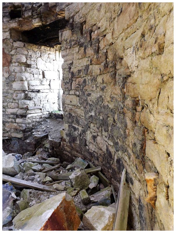
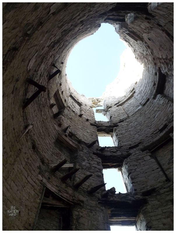
Looking to my right, I noticed an upward line of metal-stained stone showing where the stairs used to be. This would have been your first step towards an undoubtedly incredible view of the surrounding point of land and out over the surrounding waterway. |
I was amazed by how much more of the lighthouse had fallen since the lantern collapse only 3 years ago. The lantern room and its supporting floor seemed to be the linchpin that kept all of this together. I stood there & peered up at the more fragile pieces, like a slab of cornice that weighed so much I'd bet it would go halfway into the ground. It was only hanging on by half an outer wall slab, one that was already under pressure and twisting away from its base. I pictured being able to make it out here in the rental truck, but on a windy day where you could park a safe distance away & watch the onshore sea threat threaten these slabs. |
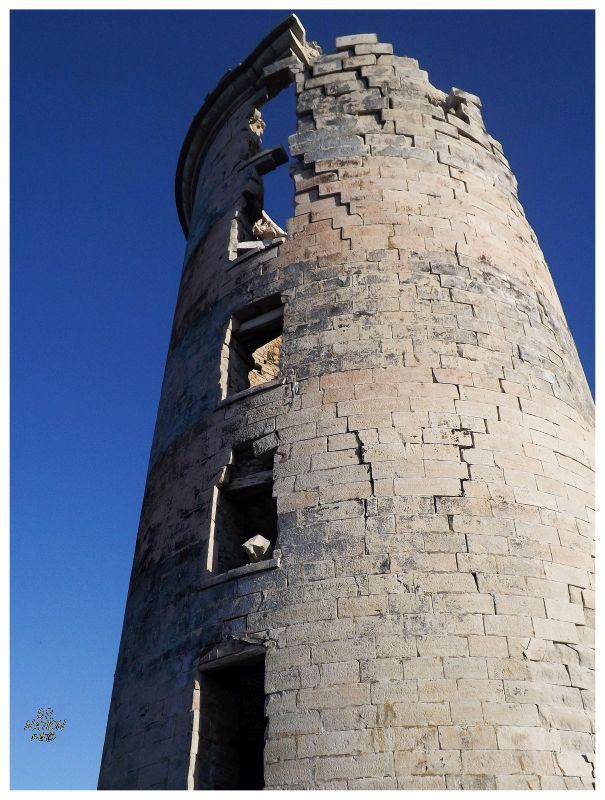
Looking closer at the blocks of stone, whether still part of the lighthouse or on the ground, they weren't as big as I imagined. The bigger parts may have been from the cornice or the supporting top wall, but there were also plenty of smaller ~100 lb pieces. Built here using the limestone that surrounds this place, maybe Southwest Point isn't as indestructible as it seems. A little crack in its armour and the sea can better utilize the freeze-thaw cycle. The wind can break off the precarious pieces and unsupported walls suddenly stand as poor windblocks. |
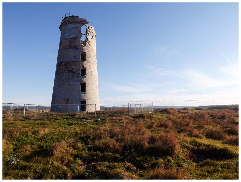
All of this had me interested in how Southwest Point will continue into ruin. The speed at which it does & the great events of collapse. I wouldn't know it at the time, but I had a lovely woman in Port-Menier to thank for all of this. It was because of her pleading with the Coast Guard that they didn't demolish this lighthouse like they had planned. Not only would I have not seen this point in ruin, I might've come out to Anticosti only to find an empty Southwest Point. It was only her pleading with them that this is a lovely, isolated and enticing location; that the Coast Guard relented and will now allow the Anticostians to watch their Southwest Point fall gracefully into ruin. |
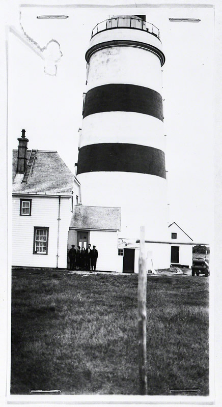
Courtesy DFO Quebec. Circa 1940.
The shipwrecks of the 1700s and early 1800s had given Anticosti Island a feared reputation amongst mariners. Situated along likely the most important shipping route of the Americas, it was important to construct lighthouses on these shores early, to keep ships to the south & away from the dangerous reefs around this wilderness. Southwest Point was the first lighthouse constructed on Anticosti Island & looking at the curve of Quebec's Gaspé Peninsula and the placement of Anticosti Island, it's easy to see why. Southwest Point cuts right into the path of those who don't sail far enough to the south. |
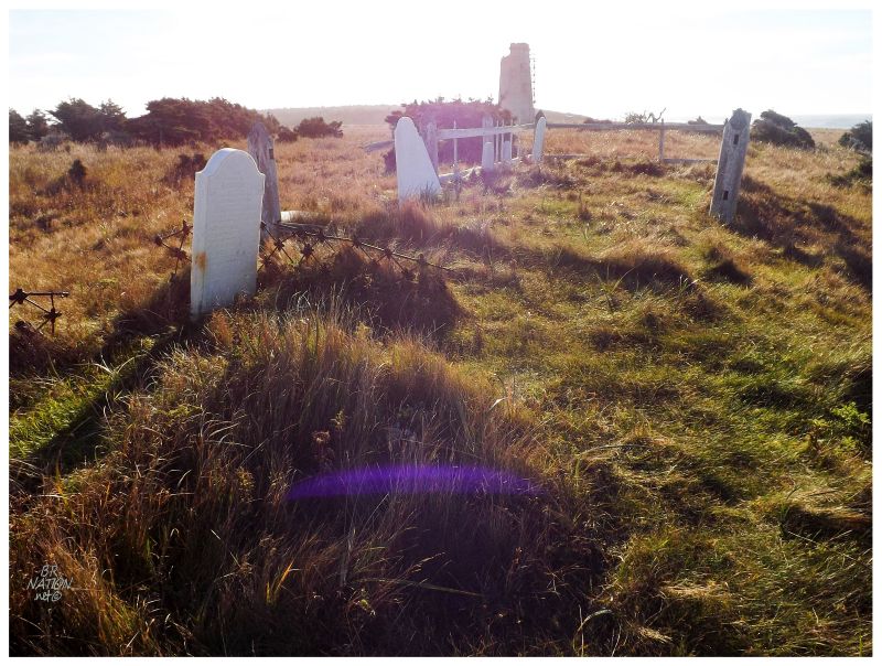
While many men kept this light during its 128 years of service, the longest lasting & most remembered would be the Pope family. I wandered over to their family plot, for 3 generations of Popes came to Southwest Point and hacked out an admirable and what seemed like a decent life. Edward Pope the first, had come here in 1840 and with his wife and growing family. A visit by James Richardson for the provincial geologist of Quebec in 1857, mentions appreciation of the cattle & horses that Edward Pope was able to keep here, as well as 3 acres of potatoes. The first Edward Pope died in 1871 and his son took over sometime before that. Edward II was another skilled lighthouse keeper in this isolated land, exhibited by a visit in 1882, where a reverend by the name of A. Whiteside from the Gaspé is quoted as saying, "This lighthouse not only stands as a beacon for the anxious mariner but also as a home for its gentlemanly keeper, Mr. Edward Pope, who with his large estimable family has resided there most of his life, succeeding his father to this highly responsible position." By 1895, there is mention of Herbert Pope at Southwest Point and his garden of rhubarb, carrots and of course, potatoes. Herbert was the superintendent of all Anticosti lights by this time & it seems the Pope family proved to be a hearty bunch, capable of handling responsibility. |
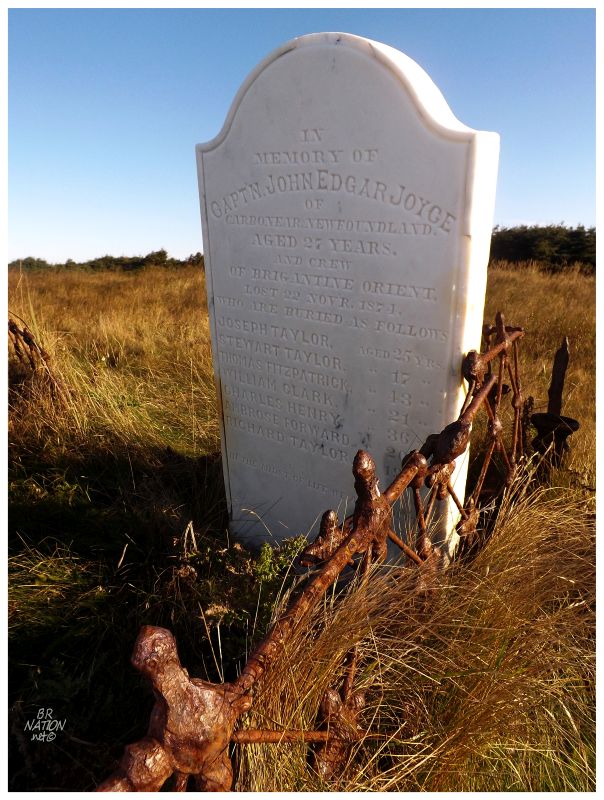
I wandered about the ten or fifteen headstones here in various degrees of upkeep. I felt a pressure to take my time and appreciate these graves out here, for how many people visit a graveyard in some place like St. John's, versus the very few people who come out here to pay their respects. It's with that respect and time taken to read each one, that I noticed a headstone for a sealing ship that crashed upon these shores on November 22, 1871. While the headstone lists 7 crewman and captain James Joyce as being buried here, there were also 6 more casualties in additional crewman who drowned (the 7 crewman and the captain froze to death). Two people would survive the ordeal, seaman Charles Moores of English Hill on the north side of Carbonear & James Joyce's brother Gilbert Joyce. |
I continued on to the physical southwest point here, where a flat, brown stone plateau like that of River Schmitt dropped off into the sea. The wide, sparse coves of Anticosti spread towards the horizon to my right & the Gaspé was far off to my left. Rounding back along the beach, I again noticed 10 or 15 hawks darting around the grasslands, coasting in the present wind then swooping and cutting at random times. Of course I didn't even try to get a good picture of the flying hawks, for it was far beyond my photographic ability. They were far away & darting, and it was like trying to shoot a picture of a hockey puck off the stick of someone skilled. In addition to taking time to stand before the sight of this lighthouse, I also put one foot up on the beach ridge and watched the sight of this group of hawks. Standing here, I didn't notice any small birds that they could be terrorizing, but as they were going down into the grasses, I suppose they could have been after voles or shrews instead. |
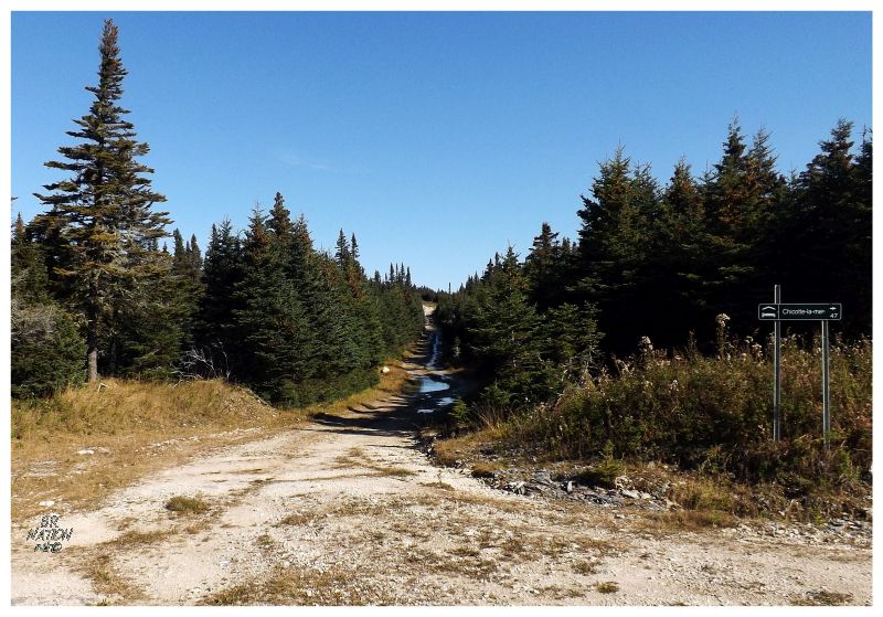
As always, you think that leaving a place will be long-lasting, but before you know it, you look back and can't even see the top of the lighthouse anymore. For how many times I reflect on revisiting places in my life and in these writings, I was pretty sure I wouldn't be returning to Southwest Point. This was the one time in my life & it was over. I reached my truck and started back up the road and again through the scraping branches. The tertiary road out to Southwest Point was only 6km (3.7mi), ending at an intersection with the road I took here & another road which would shortcut back to Port-Menier. The only problem was that this shortcut involved another tertiary road for a short section from here until the Jupiter-la-Mer lodge. I maybe could have walked down and only seen if the start was rough, but after not being able to camp at Southwest Point because of tertiary roads, I took one look at this road and decided against it. The road was steeply uphill, with deep ruts & plenty of water hiding rocks and depressions. It was a quick decision to simply take the same route which brought me here. |
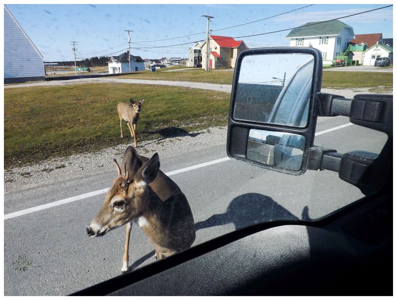
On the way back to the Trans-Anticostienne highway, a funny thing happened as I reached a peak on one of the central hills. Getting cell phone service again, I pulled over to check some things while I noticed a rare truck roaring up the road towards me. This truck slowed down as it approached and indicated for me to roll my window down. Just like everyone else here, he rushed into French conversation, where I had to slow him down & return him to English. Once we established that, he asked if I was the guy camping and again explained that people come here to hunt and not to have the deer disturbed off the road. It didn't matter much to me in this case as I had already seen Southwest Point, so I simply apologized and wished him a good day. This made me wonder how upset the hunters I passed about 10km from Southwest Point were yesterday. Anyway, cutting back across, I had to stop at the Jupiter River. This was the most famous and lucrative salmon river on the island, one where Henri Menier had a special horse-drawn barge he had pulled up the river with dignitaries to catch the many salmon. Regardless of that, I would've stopped for the beauty of the scene. The road was winding down out of the hills and I could see the attractive Jupiter up ahead, so once down at the bottom, I pulled the truck over and wandered about on the bridge, beside the bridge and up the river. Not another truck passed in this time. As much as this trip was about abandoned lighthouses, shipwrecks & housing ruins, the natural beauty of Anticosti kept poking out its alluring head. |
^The view from a rickety hunting stand that I climbed for some reason. Road to Cap de Rabast.
Driving back down the Trans-Anticostienne, it was weird & foreign how I remembered this bit, but it seemed so long ago. It's with that, that I was almost back in Port-Menier when I approached the turnoff for Cap de Rabast (North Point) Lighthouse. Cap de Rabast is only a 27 km (17 mi) drive from Port-Menier, but almost half of that is off of the main route and on the Cap de Rabast road. Driving down through forested areas with smooth gravel roads until I reached a long driveway for this lighthouse, it was neat to explore yet another different area of the island. I suppose when it's the 90th-largest island in the world, it's going to have different ecoregions & areas that feel different. |
Cap de Rabast is the westernmost of the three north shore lighthouses I've explained and explored in these updates. The only difference is that Cap de Rabast has kept its lightstation buildings in use and occupied. Where I was surprised that the easternmost buildings at Cap de la Table would have seen enough visitors and artists to make it viable, it's no surprise that Cap de Rabast is viable with its proximity to Port-Menier. |
While the above picture shows a maintenance shed, I soon realized that all of the keeper's and assistant keeper's houses were filled with hunters. I went back to my truck, parked right outside these buildings and enjoyed a midday lunch of even more Froot Loops and canned milk. I had long ago abandoned warm meals via my camp stove. Regardless, I'm a big fan of Froot Loops, and relaxing here at this lighthouse, life wasn't all that bad. |
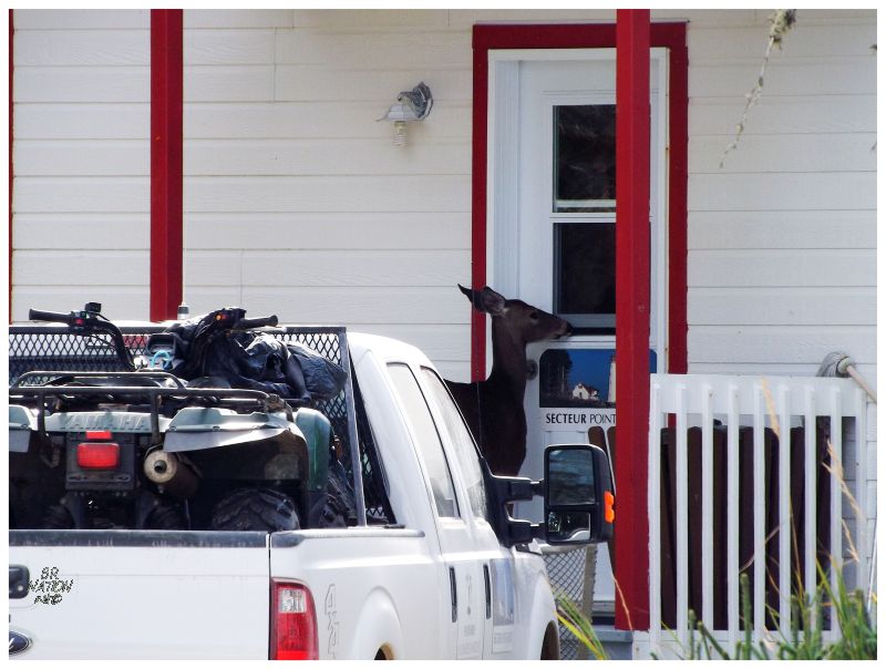
It's around here that I had a good laugh at a marauding deer breathing into this front door screen window. I pictured that snout leading into a kitchen with people sitting around eating, while in real life, a hunter then came out and shoed away said deer. It's around here that the tenants discovered me & stared out, wondering what I was doing. Another hunter came out of the closer house and looked perplexed with an angled head in my direction. Instead of sorting out the French-English conversion and having a conversation, I was just about done my Froot Loops, so I went on my way, having seen my 7th Quebec lighthouse. |
Soon enough I was back in Port-Menier, safely returning from the Anticosti wilderness with every goal achieved. I felt relieved as the truck hit the blacktop without having hit any deer and also joyous with having returned safe and sound. It was time to see if the tourist office was open for much-desired coffee, then head out to the small chunk of western Anticosti that sits to the other side of Port-Menier. Continue to Part 6, Baie-Sainte-Claire. |