Canada Day weekend was here and I'd decided I had enough things in Central Newfoundland to fill up 3 days. |

I stopped in Badger to check out their new "skatepark" but unfortunately it was raining. As I've already rode two other identical pump tracks, I only cared because I wanted to check Badger off the list and get some exercise for the day. |

My target tonight was a new campground I discovered online, the Oceanview Park Campground in Leading Tickles. Now Leading Tickles is an hour away from the TCH Bishop's Falls turnoff and I had nothing else I wanted to do in the area, but the park looked so good that I made the drive regardless. I was struggling to fill up a full 3-day weekend with stuff I hadn't already seen in Central anyway, so there was plenty time for things that might not usually be worth such an effort. That being said, and even though the nighttime low was headed towards 4°C/39°F, this was still a gorgeous, seaside site. |

Donning my rain gear, I hiked a short trail up to a platform they have on the highest hill. Leading Tickles is doing really well here by utilizing their location and creating a campground at the tip of this remarkable country. Add in being able to visit the giant squid statue, the number of icebergs I saw in the vicinity, plus the historic Jack Ward General Store, and you're starting to have a destination for tourists. This was easily worth the hour's drive, even in these not so summery conditions. |

In addition to the outlook trail, there's another nature trail that extends from the end of Leading Tickles, hooking around into the undeveloped part of Cull Island, then back towards the campground. I'd hiked part of this before, but deciding on completing the trail today, there were icebergs, as well as hidden coves and beaches along the way. |

Another highlight of the trail was the forgotten Rowsell's Island Methodist Cemetery. Rowsell's Island was a nearby village located on a small and inhospitable island where they didn't have any extra land suitable for a cemetery. The people of Rowsell's Island would instead bring their dead by boat to Leading Tickles, then haul them up into these hills and to this cemetery. |

My source of information here is the fantastic Newfoundland Grand Banks Genealogical & Historical Data website, where this cemetery was transcribed in 1990 by David Wells, who arrived in Leading Tickles and this spot was so overgrown that local resident Mark Rowsell had to personally lead him up the hill and into the clearing. Wells says that there would have been no way he would have found the cemetery otherwise. It's good to see that there are now trails and even signs for visitors. |

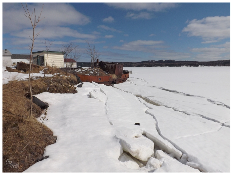
Heading out of Leading Tickles, I decided to stop and take a closer look at this old boat long ago beached in Point Leamington. |

Unfortunately I think this boat is just a little too small to have a proper history online and I'd probably have to talk to one of the local old timers. Bob's Newfoundland must've did just that, because they say it's been here for 50 years, although that's all there is for history. Regardless of a lack of history, it really is amazing how embedded it is in the landscape. If they just built a little hill, you could easily walk right atop the boat without noticing. |

I wanted to board it, but 50 years along the shore did a number to her wooden deck. Stepping onto some of the grass that covered the back two-thirds, I could see holes where only jagged metal blocked me from the rocks of the ocean below. There didn't seem to be much I was missing from this vantage point, so I got down and was satisfied with my visit. |

The slowly passing rain meant overcast pictures of the boat in Point Leamington and it also meant the skatepark in Botwood remained wet. I still stopped after I noticed a newly acquired mooring cleat from some nearby harbour. Having tried to crankarm grind one of these things while waiting for a boat in Petite Forte, I hope that skateboarders of Botwood enjoy mooring cleats more than I did. |

The afternoon was spent going to this abandoned thing that I'll cover in the next update. Following that and ahead of schedule, I decided to finally stop at this abandoned house in Boyd's Cove that I've seen since I moved to Newfoundland. Circling the exterior, the house would keep me outside, an attribute that certainly plays a role in its longevity along this busy highway. |

Following Boyd's Cove, it was only 20 minutes up to Dildo Run Provincial Park, not before stopping at the Dildo Run Snack Shack in Virgin Arm for a celebratory dinner poutine. While I want to stay at every provincial park here, Dildo Run held even greater priority because of a reference to an old tramway on their website. |

At 31 km0 long, New World Island is not small and this tramway would make life much easier. The narrowest section near the middle of this whale-shaped island is only 800m wide, and putting a tramway there enhanced the shortcut from the northern waters of Virgin Arm to the southern waters of Dildo Run. No longer did shipping require a long trip around the whole eastern side of the island all the way from Tizzard's Harbour to Summerford. The tramway allowed the postal boat to make more frequent rounds by only dropping off mail in Virgin Arm for points south, while residents could also drop off things like lumber and small boats to be transferred to the other side. It even played a role in peoples' health as residents in places like Boyd's Cove to the south, would head north to the tramway and shortcut across the land on the way to the hospital in Twillingate. The tramway's demise came in the 1950s, as new causeways were built and the main road severed the tramway on its way up to Twillingate. |

As for spending the night at Dildo Run, I was still able to grab one of the great campsites along the water even at this late juncture. This is after I refused to book online because of the ridiculously expensive booking fee of the NL Parks system. It was chilly though and the site was sort of close to others. In a place like Newfoundland with such large, empty, breathtaking spaces, I sat here and felt silly paying to camp at a place like this. At least I checked another thing off a list though! |

Heading the 20 minutes up to Twillingate to grab some breakfast the next morning, I discovered that the Canadian Ramp Company sold another pump track to another small Newfoundland town. This one had some added danger because I didn't want to hit that sand at speed, but since I forgot my air mattress on this first camping trip of the year, I was sore, tired, cold and not too keen to high-speed race around a pump track in a winter coat. I checked it off and moved along. |

Of course if I'm going to be in Twillingate, I'm going to pop out to the Long Point Lighthouse. |

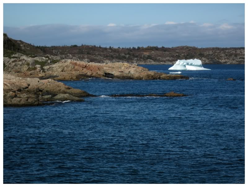
Iceberg view from the south side of Little Harbour, just outside Twillingate. In a funny bit of randomness, it's here that I ran into the lady who runs the Vietnamese restaurant in CB, who was also parked and about to walk to check out the same iceberg. |

Starting to head back, I once again went off the main road towards Pikes Arm, Salt Harbour & Herring Neck; half-assedly seeing if anyone was around or if it was even possible to take a boat out to the lighthouse at nearby Bacalhao Island. Not finding anyone around town, at least I got a nice, distant picture with another iceberg. |

I also happened upon this giant cement thing in Cobbs Arm which is one of the last two buildings standing from their old limestone quarrying operation. A.K. Snelgrove reports in 1953 that the limestone was trucked from the quarry in Cobbs Arm, down to the shore, and loaded onto schooners to be burned for lime in St. John's and also for use in the flotation mill at Botwood. If you look at the above structure in Google Earth, you can see that the inside is hollow and separated by a wall in the middle. My best guess would be that it was a storage building akin to a silo, but that is only a guess. Nowadays it serves as part of a shed. Not only would I die to have a shed that incorporates an old ruin, but the driveway I was standing on led to a fantastic, big old Newfoundland house. These people knew how to live. |

I tried to get to another abandoned thing this afternoon, but failing that, those pictures will have to wait until I successfully make it one day in the future. Afterwards I contemplated driving home, but I had all my camping gear and I was already out in Central. There would be plenty of days to sleep in Corner Brook. So, after passing Grand Falls-Windsor, I didn't go very far before I found the driveway up to Pearson's Peak. |

From the Newfoundland Encyclopedia.
Lester B. Pearson is probably best remembered in Newfoundland for being the prime minister who wanted to complete the Trans-Canada Highway across the country, and completion of that, meant completion across Newfoundland. Even in the 1960s though, the highway across Newfoundland needed so much work and was missing so many segments, that there were four separate highway-funding agreements between Newfoundland premier Joey Smallwood & the Canadian prime minister. |

Pearson's Peak, 1960s (source: CBC)

Pearson's Peak, 2017.
Finally, wanting to get the road across Newfoundland done before leaving office, Pearson committed 90% of the funds towards any stretch started between April 1, 1963 and December 31, 1967. Smallwood, appreciative of Pearson's action, adopted the slogan of "We'll finish the drive in '65 - thanks to Mr. Pearson". Signs declaring this were erected along the TCH and outside of the Confederation Building. For once things were finished on time. Celebrating the last stretch being connected, Pearson left in a car from Port-aux-Basques while Smallwood left in a car from St. John's, and the two of them met at the halfway point of the island - where a new, 80-foot-high monument was built to celebrate the achievement. This was Pearson's Peak. Featuring a glowing maple leaf and a bronze plaque, a provincial park was also established to manage the new attraction. |

Over the years, long after Pearson and Smallwood left, no one committed money to actually maintaining the monument. The woods grew in and pieces of rock occasionally broke off the monument, sometimes scaring couples who would go up here in search of a quiet place to get busy. Between 1995 and 1997, Clyde Wells and Brian Tobin's Newfoundland governments closed and sold off 41 provincial parks and 7 scenic attractions. Pearson's Peak was one of them, and the government must've either tore down the monument in maintenance while still running the park or as part of the park's closure. Online people seem to have simply forgot about Pearson's Peak, but in recent articles most people think it went away sometime in the late 1990s. Of course there isn't much to see nowadays but a cement foundation and a bit of asphalt. It still made for a good enough, secluded campsite just a hundred metres off of the TCH. A place to sit and ponder that it wasn't very long ago I couldn't have easily drove to Twillingate and just how long Newfoundland Island resisted bridges spanning its waterways and built-up roads crossing its bogs. I woke up in the morning and rode the new "skatepark" in Badger before heading home. Click here to read about the battery I explored amidst all of this travel. |