One day about 7 years ago I stumbled upon a collection of old sea kayaking blogs, where an author described landing for lunch at a spot where there were "old stone chimneys" in the woods. Even without a picture to gauge the scene, this was enough to eventually find myself basing a whole central trip on heading towards the village of Laurenceton. In my cursory preparation for this trip, I only found one other website describing this place and stating that there's an overgrown trail. As I drove right into Laurenceton to size up what I thought must be the trail, I only walked a few hundred meters before it started to deteriorate and split. If I continued and the trail petered out, it would be 3.5km (2.1mi) of bushwhacking, so I went with option B. |
Back on the highway, there was a point along the road that was only a little over a kilometer (0.6 mi) from the old chimneys. Pulling up to that point, there was a small bog where I could size up the distant hillside and memorize a point to hike towards. Diving off the highway after the next break in car traffic, I knew it was as simple as pointing myself in the direction I had already established from my car's GPS. My plan to skirt the bog worked decently, although little indents surprised me with unexpected pools of water. Before long I had happily chipped away a few hundred metres as I ducked into the approaching, post-bog treeline. The forest at first wasn't thick and I found a ridge that reminded me of the poor rock piles of Michigan's Upper Peninsula. Climbing to the top, I dropped my pack and surveyed the surroundings. Things were going well and I was already out of sight of the highway. |
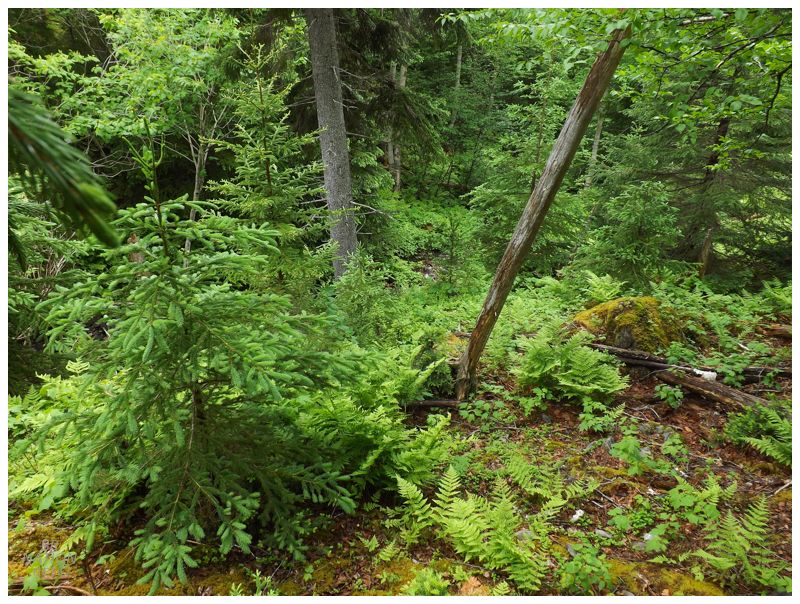
Having failed in the thick forests of Baie Verte and along the Bay of Islands coastline, I no longer underestimated the forests of Newfoundland. Thankfully these forests had open areas where you weren't chipping away meter by meter, but also, the tangled parts consisted of a lot of dead trees. I would get tangled and stuck, but almost always I could gather myself and use my weight to escape the dead branches. Things were going so good and I've worked so hard previously in Newfoundland forests, that I was certain some tribulation was about to befall me. |
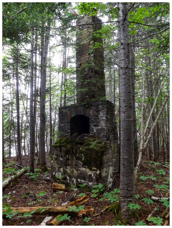
That wouldn't be the case though. The top of the hill led to multiple streams that cut down the sharp backside of this little ridge. Finding a stream that was mostly dried up, I picked my way down the rocks, while occasionally stepping to the side into a slight, streamside clearing. It's with that speed that the reward here was even more remarkable. I knew I had to be getting close from the flattening landscape and the height I'd descended. At the base of this stream, the stones turned to boulders, the forest trails disappeared and the streamside turned into thick trees that I occasionally had to swing across. Fighting through their hold, I escaped into a flat bottom and remarkably, there was my target, one of the stone chimneys. It was even more striking and splendid than I imagined. The surrounding building might have been torn down long ago, but it still spoke to what was once here. I instantly wished I had brought my camping gear to spend the night here at Wiseman's Cove. |
Across the bay, there's a well-maintained trail to the Phillips Head Battery and even a large sign that alerts you from the road. That's how I found the site in 2009 without any prior research. But once you research Phillips Head even the slightest bit, you find the same tidbit of information in almost every source, that gun batteries were installed at Phillips Head and Wiseman's Cove to protect the entrance to Botwood. This made me wonder what the deal was with Wiseman's Cove & why there wasn't any information about it readily available. The only thing I could find was this account of a group of sea kayakers who landed here for lunch because of their tour guide. The account describes standing chimneys from the old buildings in the forest, but of course doesn't post any pictures since outdoorsy people only love empty forests. I love y'all outdoorsy people and kid, but I'm obviously someone who enjoys disturbed nature with old cars or ruins. In finding this one random internet reference, that was enough for me to mark this location and jump into these woods. We're talking about a forest of standing stone chimneys from old buildings here people! |
In 1935, Canada, England & Ireland came together to develop commercial air service over the Atlantic Ocean. With a deep water port free of ice 8 months of the year, as well as being located along the Great Circle Route from New York to London, Newfoundland's Botwood made an ideal location for their seaplane base. In just four short years, the first ever Trans-Atlantic passenger flight would leave Botwood on July 27, 1939 and successfully land in Foynes, Ireland. Additional planes would come to Botwood in 1940 with the onset of WWII. Utilizing Botwood's location for reconnaissance missions and shorter flight times for dignitaries and soldiers, Canada quickly realized the port city's importance and petitioned England for control, which Canada gained within the same year. |
To further defend the prominent city and army base, the RCAF constructed gun batteries at Phillips Head and here at Wiseman's Cove. Located north of Botwood, Phillips Head marks the point where the Bay of Exploits is only 1.75km (1.1mi) wide, while Wiseman's Cove marks a point just north that's 2.75km wide. Manning these strategic points allowed the RCAF to guard the city against any naval attacks that may try to come up the bay towards Botwood. (Phillips Head is across from Sandy Point, a low-lying sand spit that wouldn't be very good for concealing bunkers or looking out over the Bay of Exploits. Therefore the eastern battery was built at Wiseman's Cove.) While Phillips Head is better known and has more information posted online - likely because of its popular trail - Wiseman's Cove was the more powerful of the two batteries. |
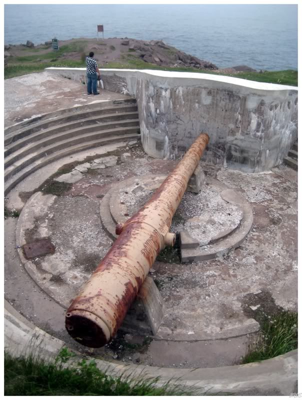
The 10-inch M1888 gun at Cape Spear, outside of St. John's. 2009.
At Wiseman's Cove there were two 10-inch M1888 guns, the same model as the impressive guns still located at Cape Spear today. The only difference is that the Cape Spear guns were mounted on disappearing carriages that only raised above ground to shoot, while the Wiseman's Cove guns were mounted on stationary barbette carriages. With the tide turning in the war, the importance of defending Newfoundland waned and army personnel started to leave to go to active wartime theatres. By the summer of 1943, infantry, anti-aircraft and coastal artillery troops were mostly removed, and the coastal batteries at Rigolet, Lewisporte and Wiseman's Cove were all mothballed by the end of the 1943 shipping season. By June of 1945, the RCAF left Gander, Botwood & Lewisporte. The coastal defenses were abandoned and returned to the Newfoundland government by the Canadians, with the temporary wood buildings quickly scavenged for building materials. While I can see wooden buildings in Rigolet or Lewisporte disappearing, I question how much wood and other building materials could have been taken from Wiseman's Cove. Then again, the forest floor was awfully clean. |
Walking in the forest, there were visible paths and I started to suspect boats might bring more people out here than I imagined. Following one path, I was surprised to find that it led to a lone seaside cabin, but thankfully no one was home. Down to the cabin's shore, I peered out over the base of the Bay of Exploits and thought again about how nice it would be to camp here, while then thinking about how thankful I was that I didn't try to come via Laurenceton. Looking at those hills, I shook my head and couldn't imagine it being very easy. |

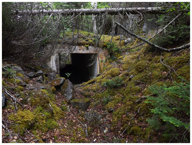
The cabin was along the side of a curving path going towards the sea. I was going to return the way I came, heading back to those chimneys, figuring the trail simply goes to some other point of land where the cabin owners have a view north, or another little cove, or some other coastal feature that I was fine with skipping. I was out here though, and while I often feel pressure to rush back to safety to "cash out" on a successful mission before things go awry, I got out here quickly enough that I was confident I had plenty of time to dawdle. I had about 5 hours to get back to the car and I needed to stop being so ridiculous. So I followed the curving path out towards the headland, eventually coming to the base of a 20-ft hill of loose boulders. |
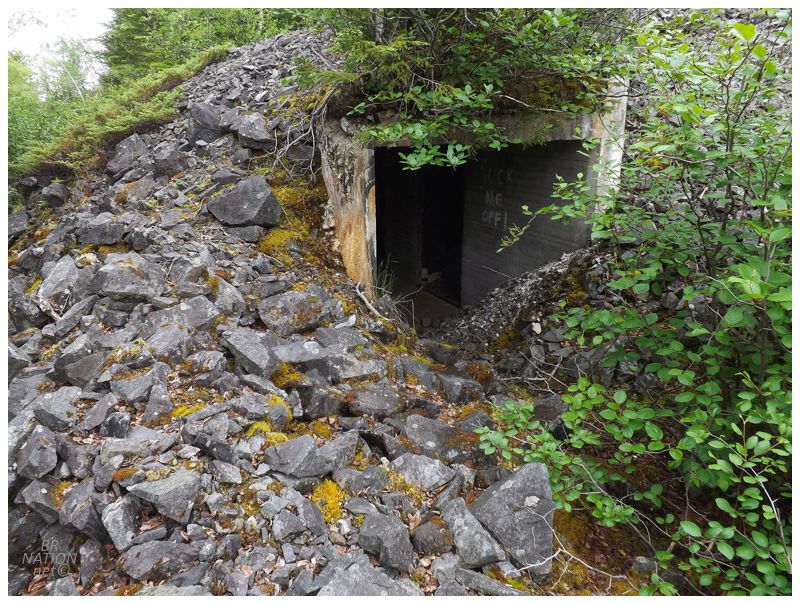
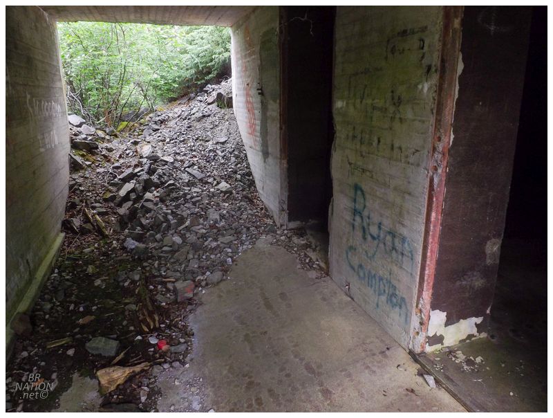
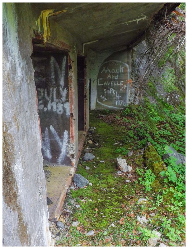
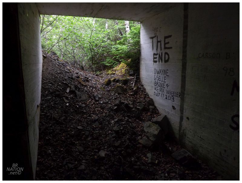
Well, well, well. There were also tunnels here!? So the sea kayakers simply came here, stepped into the woods to look at (probably only one) chimney, then went back to the cove and went on their way? Because there was no mention of any tunnels or other fortifications or ruins. |
The funny thing is that if I was better with my research prior to this trip, I might've found Alex Souchen's UWO thesis about WWII batteries in Canada, where he states that greater ruins were left at Wiseman's Cove and Cape Spear. Regardless, I was so happy I didn't simply go back to the chimneys now. This was an incredible find. |
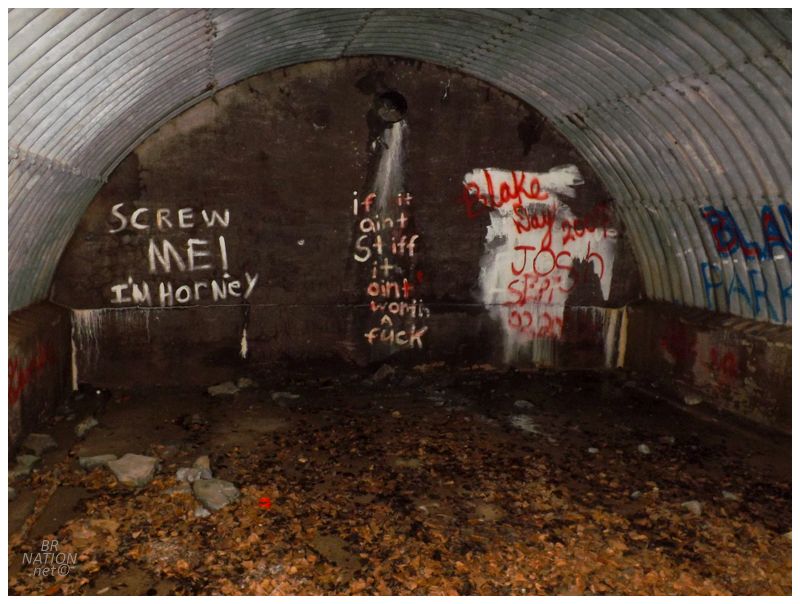
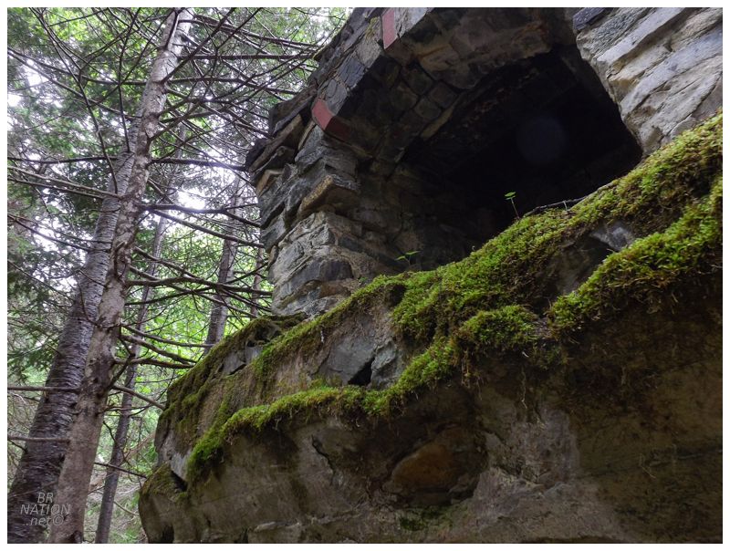
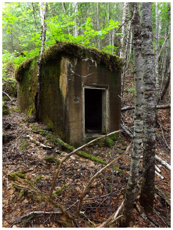
It wasn't just tunnels either, there were also the underground bunkers here just like at Cape Spear. I recently returned to Cape Spear and they've done so much work to turn that place into a museum with running electricity and information boards, while these rooms at Wiseman's Cove felt like the Cape Spear of my first visit 10 years ago (right down to the inch or two of standing water). Also, "If it ain't stiff it ain't worth a fuck" seems to be some obscure documentary involving Elvis Costello and a bunch of other touring punk rockers. Where nowadays so much graffiti is all the same hacky internet memes, I like how obscure it is for someone to have found themselves out here in the late 70s or 80s, armed with a paint brush, deciding "If it ain't stiff it ain't worth a fuck" was worth 55 brush strokes. |
Continuing along the top of the rock pile, I found another tunnel section & then another. Now when I first got here, I went down to the water at a different cove than the one with the cabin, so I knew there wasn't that much land between the two coves. That's why the amount of infrastructure I was finding here was surprising. It blew my mind that I almost missed this & that people come here and only check out the chimneys down in the hollow. Once again I was learning to be more thorough, because I was losing my mind at how cool this was, a rarely disturbed set of ruins that next to no one knows about. Outside of locals with boats, I couldn't think of many other people who would know about this except for WWII buffs. |

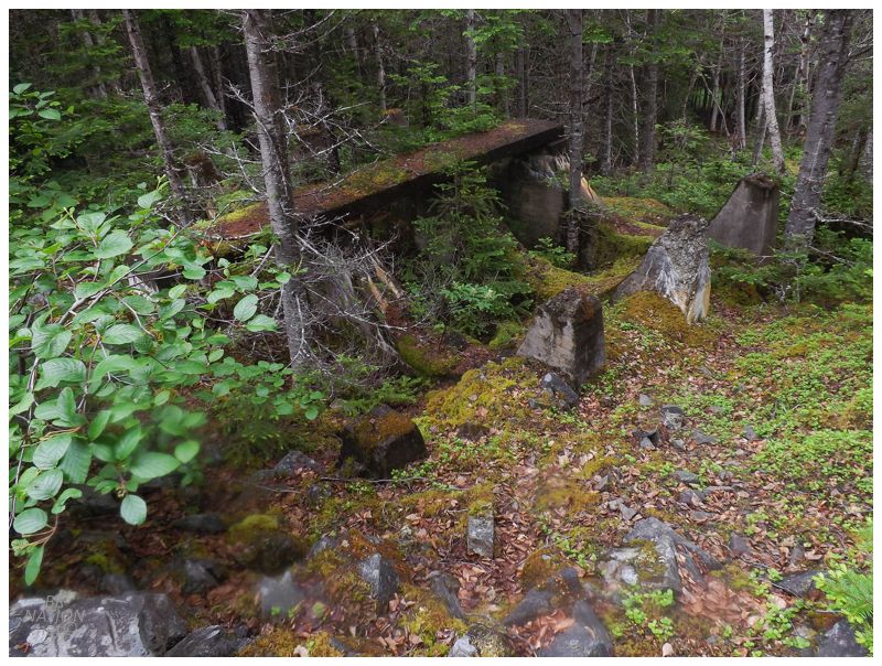
As if this wasn't amazing enough, the tunnel sections changed and I then found myself at the circular base of the old M1888 gun. Even with trees blocking the base and the view over the Bay of Exploits, it was hard not to be overwhelmed and feeling small in this giant, concrete circle. Following the war, the Canadian government was obligated to demolish the wartime buildings they constructed on leased land. In order to do this, they often contracted the work out to companies who wanted the scrap value associated with these buildings and weapons. In Newfoundland, the Montreal-based firm of Joseph Sasseville stepped in and purchased over 100 wartime buildings from the Canadian government, with the stipulation that places like Cape Spear, Botwood and Wiseman's Cove would be returned to their original state, with buildings demolished and debris removed. |
A problem arose when Joseph Sasseville balked at the removal cost of the 10-inch guns from both Cape Spear and Wiseman's Cove. The Canadian government said this was fine (because they also didn't want to spend the money if Sasseville failed), but the Newfoundland Department of Natural Resources stepped in with their displeasure. Thankfully for the Canadian government and Joseph Sasseville, the original land leases were nowhere to be found. The stakeholders and the feds couldn't be held accountable, and the guns with their emplacements were left to decay in a forest (Wiseman's Cove) or later surrounded by tourists (Cape Spear). Only two years later, officials were already contacted with scrap requests as well as reports that some of the guns were missing. There isn't any concrete reference to what happened at Wiseman's Cove, but the War Assets Corp stepped in and scrapped most of the guns and cleaned most of the WWII sites by the end of 1950 (Souchen, 2016). The funny thing is that very few 10-inch guns from WWII survive today and most of them are in the Philippines. Away from Fort Casey in Washington which acquired a few of these guns back from the Philippines, the only remaining examples of the M1888 stand at Cape Spear and Fort McNutt in Nova Scotia. |
Going back to the graffiti, where I was excited that someone in a nearby place like Laurenceton or Porterville was interesting enough to know that obscure Costello documentary, I forgot that it might've been an outsider. At Botwood's Killick Island, there's graffiti from Akron Ohio and it looks like it's from an old member of the military. So who knows if someone similar also came here. If you were stationed at Wiseman's Cove during the war, I imagine it would be easy enough to convince someone from Laurenceton to bring you up here by boat. |
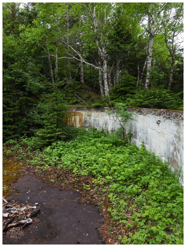
Cement foundation for an old oil tank.
Climbing down from the rock pile and segments of tunnel, I heard some guys in a boat who sounded awfully close. The trees were thick enough to conceal me, and before I could even think about saying hello, they were gone. I wondered if they heard me loudly singing Ahead By A Century to myself. |
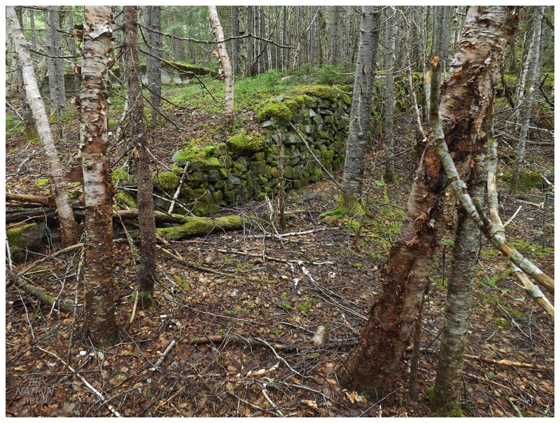
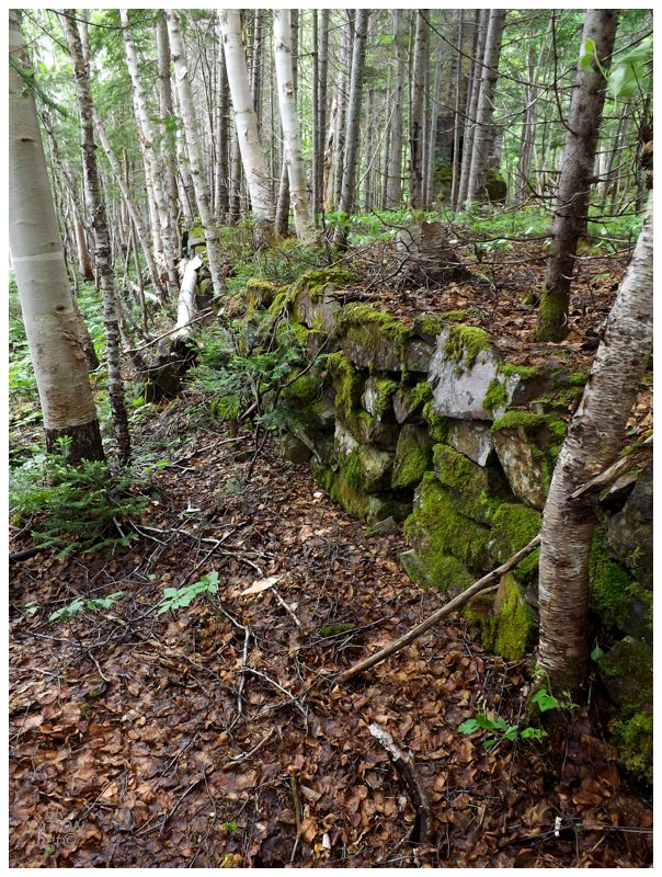
Throughout my walkabout, there were a few hand-built rock walls, which seemed really strange for a big operation like the Royal Canadian Air Force. I know of another place in Newfoundland where POWs built rock walls, so I wonder if that was also the case here? Or maybe it was a way of camouflaging the bright concrete? I guess exploring such an obscure site has left me with more questions than usual. I was also thankful for the climate of Newfoundland, since a more lush locale would likely have vines and trees hiding a lot of these ruins. |
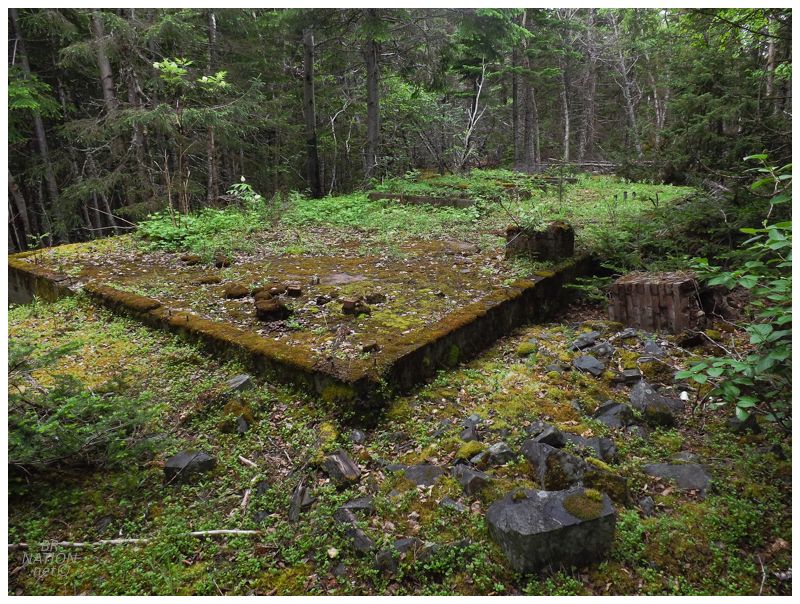
While the chimneys down in the valley seemed like they belonged to wooden houses because there was nothing else left behind, I found some cement foundations up near the oil tank holders and the tunnels. (Also note the square of chimney toppled over on the right.) It would be great to get a map showing the purpose served by each of these foundations and rock walls, but seeing as that doesn't even exist for a huge base like Stephenville, I can't see it happening here. |
I was in no rush but felt like I'd now done Wiseman's Cove justice. Choosing a different stream up and out of this cove, the new creek worked even better and after only one or two fights with tangled brush, I quickly found myself back at my car, extremely happy that I finally drove all this way, bushwhacked this distance, "just for some chimneys in the woods." |